We saw in these days The rugged terrain and theory of plate tectonics , with the limitations of the book's illustrations, so we will use this small space to include some links to animations and presentations that will allow us to understand better the effects of plate movements and how it affects the topography of the Earth.
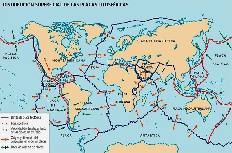
Planisphere with the division of the earth's plates, direction of motion, speed and collision zones (image obtained from astroyciencia.com)
As we discussed the origin of theory were Wegener studies on drift continenta the early twentieth century, showing the movement of continents, but until mid-twentieth century were not answered all the unknowns, explaining the effects of the division of lithosphere large plates that move over the surface layer of mantle.
Some animations that show examples of how to act plates and their effects on the formation of relief by clicking on the links (they are in English but the pictures are very clear):
divergent Borders forming an oceanic ridge : the plates are separated and creating new ocean crust under the edges
converged creating a coastal mountain range: a fascia ocean sinks (destroying bark) under the other plate and stand (appearing a mountain range and associated with volcanic areas)
You can see other animations on the following website:
http://www.juntadeandalucia.es/averroes/manuales/tectonica_animada/tectonanim . htm
To follow a full analysis of the tectonic plates in the following format (it is extensive, as it is raised to 4 pupils) Presentation Plate Tectonics (Pablo Fernández Moreno)
Other known effects of plate tectonics is the volcanic activity that is associated with:
 Court
Court a typical volcano with major elements (image obtained from defensacivilmaimon.wordpress.com)
have recently recorded the closest images of a volcanic magma (the Maroum) for a documentary directed by photographer Geoff Mackley are impressive.


